
Background: From past decade, ecological imbalance is causing huge impact on biodiversity of the planet earth. To ensure sustainable future for our next generations, biodiversity conservation is an important task. According to the FAO's Global Forest Resources Assessment 2020, the world has a total forest area of 4.06 billion hectares (10.0 billion acres), which is 31% of the total land area. More than half (54%) of the world's forests is found in only five countries (Brazil, Canada, China, Russia and the USA). One among the major reasons of ecological imbalance is caused by wildfires. Human caused wildfires (Global warming, Electric line & Camp fire) and Natural wildfires (Lightning, Thunderstorms & Dead trees rubbing) are the types of wildfires. The wildfires in the above listed countries have greater impact globally. Uncontrolled wildfires cause huge threats. Fast spreading wildfires take lot of time to combat and result in huge loss of flora and fauna of the particular region and thus cause ecological imbalance. On average, more than 100,000 wildfires clear 9-10 million acres (3.6-4 million hectares) of land in the world every year. In recent years, wildfires have destroyed 12-13 million acres (4.8-5 million hectares) of land. Furthermore, there are ecological, economical & social impacts as well. Wildfires also causes rise in Global warming & respiratory disorders. There have been lot of concerns and discussions regarding this recently and the researchers are still in the process to find effective and ecofriendly, cost effective approaches to prevent and detect the occurrence of wildfire. At present there are systems that are practically implemented to detect the wildfire. These systems successfully detect forest fire but are inefficient to prevent them in advance. These systems are failing miserably to combat wildfires. Hence there is a need to raise a concern regarding the prevention of wildfire by observing the climate changes in the region and monitoring the forests. We believe our approach to this problem helps in addressing this global concern to help conserve the rich culture of wildlife.
Demo Video
Project Proposal
1. High-level project introduction and performance expectation
Purpose of the Design
Ecological imbalance is causing a huge impact on biodiversity of the planet earth. To ensure a sustainable future for our next generations, biodiversity conservation is an important task. Habitat destruction is a major cause of biodiversity loss. Habitat loss is caused by deforestation, overpopulation, pollution, global warming, forest fires and many more. Among these Forest fires is one of the aspects that hasn’t been given required attention.
Forest fires aren't always detected in the early stages, by the time they are detected a lot of irreversible damage is already caused, and extinguishing them becomes a hectic task. The accuracy of prior satellite-based and surveillance-based systems for forest fire detection had limitations such as the long scanning period, low resolution of satellites, difficulties in manual installation of camera in an appropriate position and the destruction of components to high intensity fire.
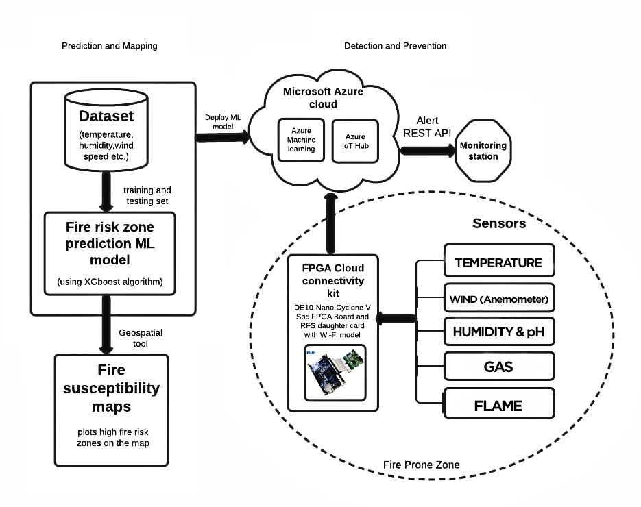
Our project addresses this problem to achieve the early detection of wildfire before it spreads to the entire forest by mapping the vast dense forest into individual regions which are analysed with the help of cloud services. The fire vulnerable regions are monitored continuously with respect to different parameters with the help of sensors implemented on FPGA kit.
2. Block Diagram
3. Expected sustainability results, projected resource savings
Performance Paramaters considered at the beggining of the project:
1. Preventing wildlife directly maintains ecological balance.
2. Reduces large scale destruction of flora and fauna and atmospheric changes.
3. Minimize manpower and fuel used to combat wildfires.
4. Cost effective way to track forest and survey biomass and biodiversity.
5. Ensure sustainable and safe future with respect to environment and nature.
6. Using renewable energy (Solar power) to power the kit ensures Sustainablity growth and pave a way for cost effective prototype and saves natural resources.
The benefit of using FPGA in this case is, it enables the prevention and early detection systems that should be updated and tuned over time. Training the data is important part of the model. FPGA will reduce overall system design and provide high functioning system with low power consumption. In remote nodes of forest, storage and maintenance of the system is important. Hence, FPGA system is a better option and it is cost effective as well.
Future scope of this system drives into analysis, training and storing data on host processors and enhancing functioning capabilities.
4. Design Introduction
Purpose of the design:
The project design mainly focuses on monitoring forest fire. Monitoring of the potential risk areas and an early detection of fire can significantly shorten the reaction time and also reduce the potential damage as well as the cost of that fire may cause.
Accurate mapping of forest fire prone zones provide excellent facilities for sound decision making in sustainable forest management scenarios like wildfires hence reducing extinction of different species of flora and fauna. therefore to ensure sustainable future for next generations, it is necessary to prevent wildfires and to effectively combat it.
Application scope:
The Forest Fire Detection and Monitoring System uses real-time data downloaded by the government department using the MODIS receiving station. The MODIS and ancillary data are used to identify the affected areas, and geographic information for locating the fires. Subscribers receive alerts during any fire breakouts. Additionally, with the mapping application, the user can view fire hotspots that occurred over a specified period. The Department of Forest maintains a database of subscribers including officials that could be given access to the fire monitoring systems. Users/beneficiaries fall into three categories:
1) Members of forest community groups receiving alerts to better respond to fires
2) Researchers and Departments of Forest studying forest fire patterns for future management strategies
3) Officials concerned with fire suppression.
Why FPGA:
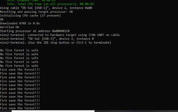
The FPGA can be re-prgrammed to suite our requirements and can be debuged easily. As it does not have a fixed instruction set there is a wide range of instuctios that could be used for the design. The DE10 Nano kit along with the on board sensors and provision given by 2x5 ADC Header make it posssible to integrate external sensors thus making it suitable for forest fire detection system. The Wi-Fi connectivity module helps in cloud connectivity so that data could be sent to the cloud in real time for further processing and alerting during forest fire scenario.
5. Functional description and implementation
Our proposed model has 2 phases:
1. Mapping of highly probable wildfire regions:
We start with studying the nature of the forest and the factors that affect the occurance of fire in the region. This study helps us in Mapping the hotspots by computing the probability of occurance of fire by Machine Learning models and deploying these models on Azure cloud for continous monitoring purpose.
2. Early Detection of Wildfires:
The hotspots mapped in the previous step are our area of study where the FPGA cloud connectivity kits are placed. These kits are equipped with various sensors for measuring Temperature, Humidity, Flame detection, Gas sensors, Wind sensors for monitoring these hotspots clearly to understand the behaviour of forest fires and these sensors help in early detection of forest fire and alert the responsible authority.
.png)
fig. a) Software Flow Diagram
.png)
fig. b) Hardware connection Diagram
.jpeg)
Fig. 3 Smart Kit with Loom Solar panel source.
I. Software Flow diagram: Software part of the project is mainly focused on Predicting and Mapping the forest fire vulnerable hotspots clearly on the map.
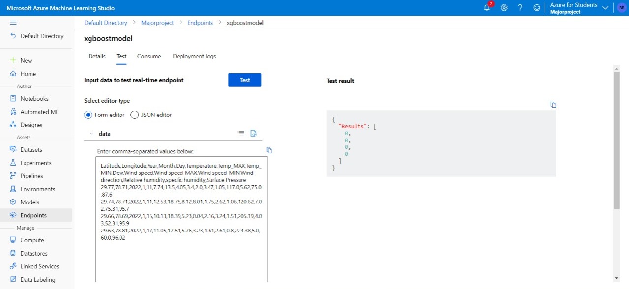
1. Prediction of Probability of fire occurance in a region: The dataset consisting of the climate parameters that affect wildfires such as Tempaerature, Humidity, Dew Point, Wind speed, Pressure,etc. are collected and are processed and divided into training and validation set to train and test the ML model.
So first the training set is divided into construction and prediction set. This will be used to train the model and to check whether the model is able to predict the required result efficiently and accurately. Several Machine Learning algorithms have been tested and performance evaluation for each algorithm is done. And based on the evaluation XGBOOST algorithm is chosen to optimize the model.
This model is then fed with the validation set data to predict the probability of fire.
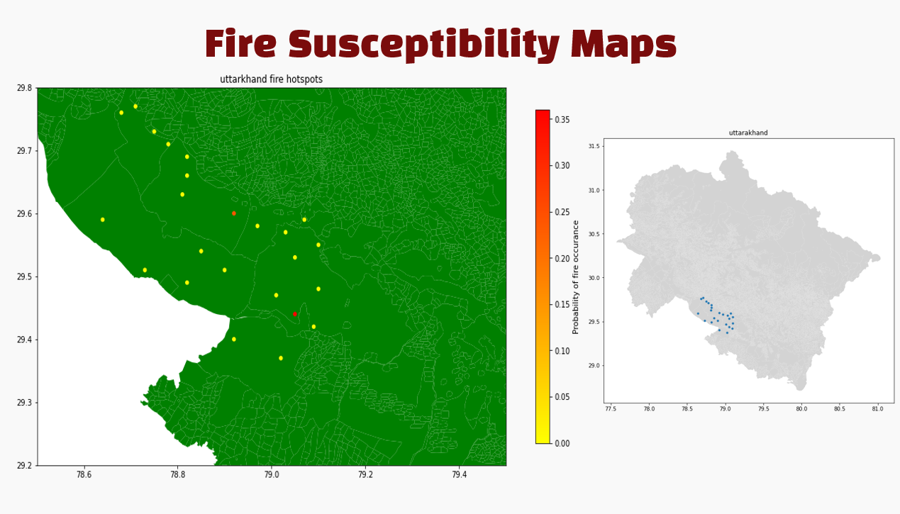
2. Mapping of the highly fire prone regions The predicted output from the previous step for the given data is used to map fire hotspots in the region using a geospatial tool. The mapping output predicts the regions where the probability of fire occurance is greater than a particular cut off. These hotspots are our regions of study to understand the behavious of forest fires and thier behaviour towards different parameters which could vary for every forest under consideration.
The above model is deployed on Microsoft Azure Cloud for remote access of these data and continous monitoring of data for the model considered.
II. Hardware Block diagram: The DE10 Nano SoC board is the main focus in this project. The DE10 Nano provided with RFS Daughter Card which has inbuilt Wifi, Bluetooth, Sensors such as Temperature, Humidity, Accelorometer, etc. We have made use of this inbuilt sensors for Temperature, Humidity measurements as they are correlated to the fire occurance. RFS Daughter Card is connected to DE10 Nano Board using JTAG Cable through GPIO 0 pin of the DE10 Nano Board.
We have also used IR Flame Sensor which is used to measure the presence/absence of flame in the IR range. IR Flame sensors are connected to DE10 Nano board using ADC pins where we have connected as shown in fig.b)
These sensor values are continuosly processed and sent to Azure's cloud services IoT Hub where it undergoes various computations and send an Alert message in the form or HTTP or SMS services to the respective organisation or person if any thresholds are crossed.
We have used Loom solar panel to power the Smart Kit. Throughout the day, the Kit will be powered directly from the Solar panel via Voltage controller. We will charge batteries also simultaneously so that we can use them as a source during Night time.
6. Performance metrics, performance to expectation
Deviation of various parameters from our actual design:
1. The range of the sensors: The sensors that we have deployed in our design have the range comparitively lesser than required for the identification of fire for reach of forests. The solution could be using the industrial sensors which have larger ranges.
2. The Cloud connectivity: The IoT Hub provision to the Azure cloud is to be achieved for the DE10 Nano board in the coming days for sensor data accumulation and alerting purposes.
3. DE10 Nano board has better performances as it is composed of both FPGA and HPS functionality in a single board that helps us with lot of functionalities.
7. Sustainability results, resource savings achieved
RESULTS:
Temperature Humidity Sensor Outputs:
.jpeg)
Flame Sensors Outputs:
MAPPING OUTPUTS:
8. Conclusion
This project can play a crucial role in preserving the foliage and forest covering one of the most biodiverse regions of our country i.e Uttarkhnad's Jim Corbett national park region which has enriching biodiversity and is more susceptible to wildfires in the recent years. Although most of the wildfires occuring in our country are Anthropogenic in nature the study case of Uttarkhand poses an exceptional case of natural wildfire due to the nature of the forest.
Thus proper understanding of forest fire prone regions in detail and the behaviour of the forest fires towards different climate parameters help us in observing the severely forest fire prone zones in close proximity by installing our study kit in these places.
The outstanding capabilities of DE10 Nano Cloud Connectivity kit along with sensors from Ananlog Devices make the prevention of forest fires to a greater extent when they are placed in these regions of study. The sensor values recorded from these values are very crucial for deep understanding of the very nature of forest fires and the affect they have on different weather parameters such as Temperature, Relative Humidity, Dew Point, Wind Speed, Wind direction, Pressure, etc.
The proposed solution in this project is capable of not only detecting forest fires, but can also accurately predict regions prone to forest fires in the near future through the continous monitoring of the above mentioned parameters which may vary for different forests.
Thus this whole system of Forest Fire Mapping and Prevention model provides an encompassing method to solve the problem of constant forest fires in the region of study.
The occurances of wildfires in the recent times have raised a lot of attention globally due to the devastation caused by them to the flaura and fauna which reside in the regions of concerns. Thus Conservation Biodiversity will inturn pave a way for Sustainable Future for all of us and the future
generations to come around because as it's always said Prevention is better than Cure.
It's high time for all of us to awaken and address the importance of the prevention of biodiversity from wildfires with the help of emerging techologies such as FPGA, Cloud Services and various Sensors for sustainable future ahead.
Thank You.
1 Comments
Please login to post a comment.
AP044
https://github.com/ravilbellubbi/InnovateFPGA-AP044
This repository comprises the details (code, details, considerations etc.) of our proposed project.