
With climate change and water scarcity, arid countries' policies aim to conserve dams’ water for domestic and industrial use only. Due to a lack of budget, having no other alternative, Small-farms crop production turns to the use of innovative low-cost solutions for irrigation and livestock. The proposed project outlines a new approach supporting agricultural agencies and policies at all levels, livestock professionals, smallholding farmers, and local populations, to stabilize the ecologically unsustainable exploitation of the water on dry-lands. The proposed approaches aim to implement Edge Artificial Intelligence on Intel FPGA and Microsoft Azure cloud computing for the prediction of water quality and its evolution, manage an innovative irrigation process, livestock watering points, as well as artisan activities (pottery...).
Demo Video
Project Proposal
1. High-level project introduction and performance expectation
The problem we are challenging to solve, tackle environmental issues in dry-lands, commonly subject to water scarcity, extreme climate conditions, and damaging human activities, making endanger the agroecosystem and local economy. Final integration engage farmers, shepherds, entrepreneurs, local managers, and other economic empowerment actors.
Often, dry-lands (see fig-1) are characterized by vulnerable soils, thin and poor in organic matters, hence the fragility of their ecosystem, in southern countries those lands suffer from pastoral overload; the expansion of agricultures’ not adapted to the environment, in addition to the desertification result of the actual climate change conditions.
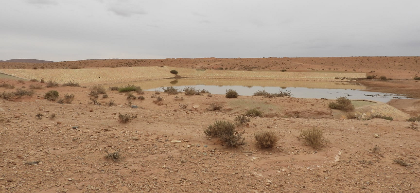 A: Dry-land with water point.
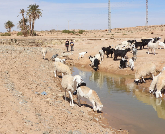
B: Livestock in dry-land with water point.
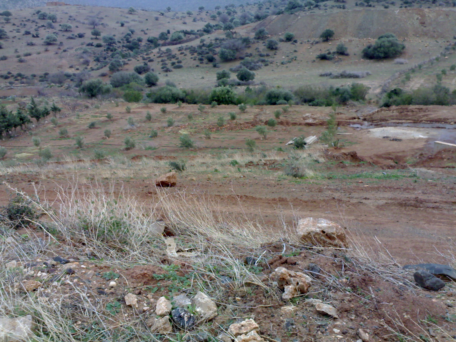
C: Small crop in dry-land.
Fig-1: Dry-lands Agroecosystem
This project aims to implement over time water monitoring as a smart technology solution to help sustainable optimized agroecosystem management on dry-lands (see Fig-1), augmented with protection of pastoral and agricultural areas. The main objectives propose strategies related to water resources management and brings Intel FPGA, and Microsoft cloud computing innovative low-cost technological tools for the water monitoring station to foster environment-friendly protocols. Acting as an IoT, the measurement station can be cloned on existing water points and new ones: boreholes, ponds, small dams, these networks in addition to water monitoring helps to tackle environmental issues to protect and preserve the environment and the global ecosystems of dry-lands, manage the access to protected range-lands, agricultural development, minimize displacement of sheep herds, which brings more stability for the nomadic dry-lands population.
The overall project concept aims to take benefit from Intel FPGA, and Microsoft Azure, low-cost innovative technological tools, to manage overtime, water quality, crop irrigation, livestock activities. Hence address water scarcity and unsustainable exploitation of range-lands. The project goals aim to develop and implement a smart water quantity and quality monitoring system. All goals are interdependent, based on innovative and adapted technologies, enable new governance models to cope with the climate change conditions in support of the circular economy.
2. Block Diagram
Our idea regarding the ecological solution, as shown on figure-1 comes down by embedding the DE10 Nano development board, making it possible to give an instantaneous indication of the quality of the water. These stations are meant to be located upstream of the agricultural orchards, within the watercourse. An optional The D5M camera can add additional edge AI futures as motion detection and object counting, related to livestock activities.
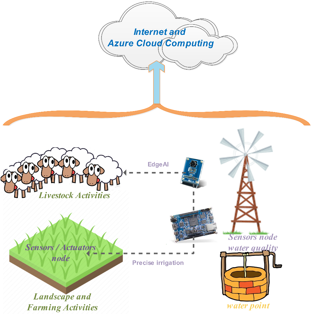
Figure-2: Modules disposition and utilization. The DE10-Nano board and connected sensors are
placed water point (usually wind pump. The DE10 Nano board measures water quality, and is connected with agricultural orcads Sensors actuators for precise irrigation. AI and EdgeAI helps to estimate neigboring livestock activities. The cloud provide the ability to deploy IoT stations network.
The AZURE solution is used both to study the plants' texture on the ground, as well as the detection of markers delimiting authorized pastoral areas.
3. Expected sustainability results, projected resource savings
Expected outputs from this project are:
- Help on water scarcity management by forecasting new technological tools that monitor water quality.- Protection of water resources, i.e. by management adapted to sustainable ecosystem functioning.
- Cloud-based software tools to enhance the knowledge regarding land degradation and desertification.
- Help to restore soil fertility in semi-arid climates based on cloud solutions and Artificial Intelligence AI.
- Provide smart tools for precision irrigation on arid lands. Optimized balance between soil evaporation and plant transpiration to improve plant water status and soil/water productivity.
- Help to build a decisions support model based on cost-effective technological solutions and applications to help policies agricultural communities, livestock professionals, and local populations to stabilize ecologically unsustainable exploitation for pastoral lands.
- Decentralized landscape management tools for long-term sustainability regarding pastoral and farming activities.
- All new FPGA, and cloud, technological solutions help to investigate new business models to support the local population economy and promote company creation based on digital tools and optimized environmental protocols.
- Improved circularity and decreased greenhouse gas emissions in drylands agroecosystems sectors, as well as productive resource exploitation.
4. Design Introduction
The smart surface water monitoring at basin level will use remote-controlled stations based on Intel edge-centric FPGA board. These stations’ networks and measurements will be managed remotely through Microsoft Azure developed solution, as shown on figure-3. The remote-controlled station tasks deal with water quality parameters, several mineral and solid substances are to be predicted before any water use or re-use. The measures come from flowing water and its elements. The IoT network will help on irrigation processes, and provide useful tolls to optimize irrigation and water productivity, for the small neighboring farms, in terms of adequacy, equity, and frequency.
The DE10-Nano is interfaced with Optical sensors array and is responsible to read water phisical and chemical composition. Acting as a spectrophotometer, will serve multiple purposes, and assess if current water quality complies with the standards.
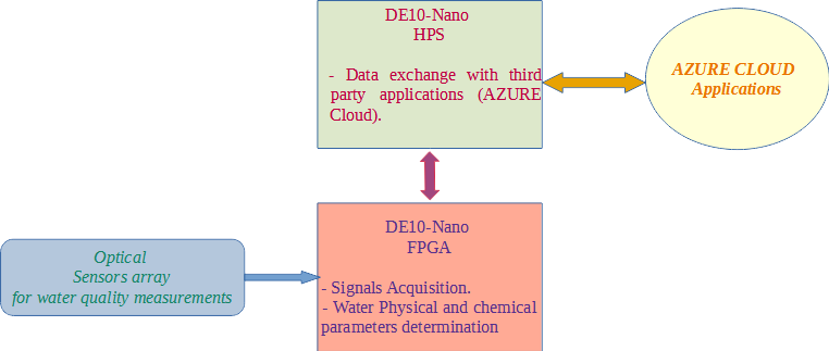
Fig-3: Functional diagram showing the DE10-Nano board operation on HPS Cyclone V Components.
All stations are paired with AZURE Cloud applications to :
- help to plan site-specific crops, and livestock,
- avoid the proliferation of waterborne diseases, additional models can be designed to detect pollution and to identify its sources as soon as the first signs are detected,
- AI modeling are used to produce geographic maps and identify the spatiotemporal evolution of the physicochemical parameters on the surface flowing water.
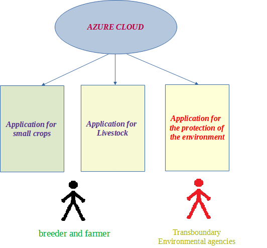
Fig-4: Cloud based application and relevant users.
5. Functional description and implementation
We do not want to replace laboratory analysis, but to make them more efficient. Stations are meant to be located upstream of the agricultural orchards, within the watercourse. The development and production of station with a set of optical sensors making it possible to give an instantaneous indication of the quality of the water. The schematic of fig-5 shows the proposed sensor and fig-6 the PCB of the board.
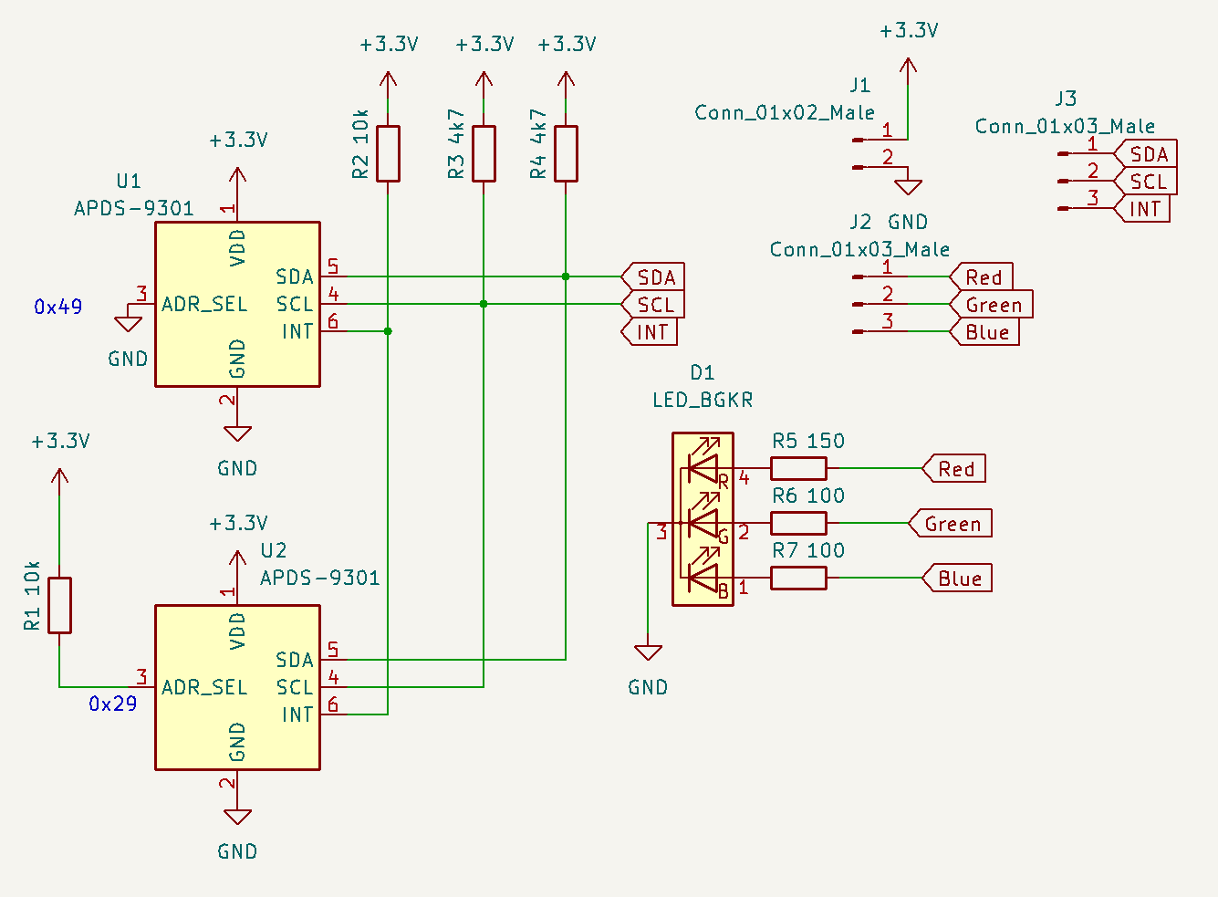 Fig- 5 Proposed Water quality Sencor Schématic.
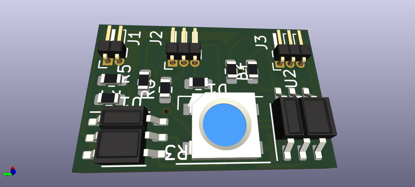
Fig- 6 Sencor PCB othe wtar quality sensor.
Recorded values will be processed by algorithms programmed to select the appropriate type of treatment according to guessed water quality and pollution. The sensors in question is controlled via the DE10-Nano to analyse all three categories of parameters dissolved and transported in the liquid mass; as it happens.
The DE10-Nano FPGA Side will include the water qualioty sensors drivers, first to generate the measerment wavelength the entity is shown on fig-7 and second to read the optical signatures fig-8. laboratory measurements are combined with station measurements for the AI model on the cloud.
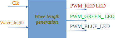
Fig-7 : Wave length generation entity
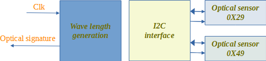
Fig-8 : Sensors entity, Water quality is estimated based on the two sensors otical signatures
6. Performance metrics, performance to expectation
The station is proposed to deal with three categories of parameters, physical ones, organic chemical parameters in addition to chemical and heavy metals cotenants.
-
Physical parameters: suspended solids, Carried solids, Colloidal particles, PH, Temperature, Conductivity, Turbidity.
-
Organic chemical parameters and heavy metals: COD (chemical oxygen demand); BOD (biological oxygen demand); Dissolved oxygen; organic materials; Dry residues.
-
Nitrogenous materials: NO3, NO2, NH4, N2, N Kjeldahl.
-
Phosphates: PO4, PTotal.
-
Chemical parameters: HCO3, Cl, K, Na, Mg, Ca, SO4, Mn.
-
Heavy metals: Cr, Fe, Al, Zn, Cd, Pb, Ni.
Water samples will be collected at different levels for in situ and laboratory analysis. Parameters analyzed in situ are water temperature, air temperature, pH, and flow rate. Laboratory analyzes relate to organic, biological, and chemical substances, in addition to heavy metals. The assumption will help to:
-
Remote station sensors calibration.
-
Correlate between laboratory results and digital estimated ones.
7. Sustainability results, resource savings achieved
The project actions are to be carried out taking at the Oued Mouillah watershed, between Algeria and Morocco. The geology of this 2.650 km² watershed, indicates the preponderance agricultural land with high agro-pedology value. The climate in general, is semi-arid with an average rainfall of 280 mm per year. The economic activities of the rural populations, are based on agriculture, artisanal pottery, and small-scale tourism. This watershed receives different levels of uncontrolled wastewater discharges, which are carried downstream by the water flow.
Sustainability actions conducts a study on how climate change and economic growth may impact Water-Agriculture-Health. To define the flowchart of measurement to be followed to ensure agricultural and by-products sustainability on rural regions by the satisfaction of a flow of purified water having no impact on health. This is very important since it defines the scenarios between the different actions linked to:
-
Continuous climate change conditions are seriously affecting agricultural yields and water quantity and quality. Indeed, the study area is semi-arid, facing high fluctuations in pluviometry and other climatological factors as temperature and evaporation.
-
Water quality, affected by the various domestic and industrial discharges.
-
Agriculture depends on river flow to guarantee higher crop yields trough irrigation, which is directly linked with climate change and water quality. The reduction in the rivers and wadis water flow and its poor quality affects crop yield and value.
-
Health is an important action as it is related to water quality. Pollution of the watercourse has a strong impact on water-borne diseases.
Proposed decision support systems (DSS), and connected applications affect different partners. The Cloud based DSS provide a solution for remote monitoring of land degradation. All data come from remote sensing and on the ground local measurement stations. All measured data remain proprietary and will be accessed from cloud solutions. The DSS enables large-scale data surveys and markets. DSS tools are used to promote the farming protocols, certify products and promote the Agricultural association to start a new label scheme based on blockchain technology. All digital tools aim to support and assess products based on low-cost effective agricultural practices, for crops with low working capital. DSS takes benefit on water quality stations, cloud-based application, and Artificial intelligence. water quality is being used as an advanced time factor diagnostic tool, this opens the way to the deployment of automated applications that links the history of lands state livestock and crops. Governmental agencies and consumers will be able to analyze over time the history of the planed agricultural activities. Artificial Intelligence and deep learning, will provide the knowledge to correlate between pilot site activities and others.
8. Conclusion
Highly affected by the climate change factors, many countries actually are subject to greater drought periods, lasting for many years, leading to gradual depletion of both surface and underground water resources, increasing pollution with all its nuisances. The issues of water scarcity and contamination become a question of survival, explicitly during epidemic times.
The alternative comes with smart and real time monitoring of the surface water quality to optimize its management, being this solution proposed as part of this project.
The monitoring station will bring the application of the technologies of information and communications, cloud computing and artificial intelligence (AI), through the production of collaborative protocol between: in-situ sensor analysis stations, advanced laboratory analysis, and modern irrigation network with precise management software and sensors.
Small national companies can be created to manage information and decision systems for water quality monitoring and precise irrigation management. The proposed information system makes it possible to large scale and transboundary exploitation of water quality analysis. The decision system improves the positioning of wastewater treatment plants, besides simplifies the irrigation process selection and control. All Stakeholders are encouraged to use connected software applications de manage resources and access data
0 Comments
Please login to post a comment.